


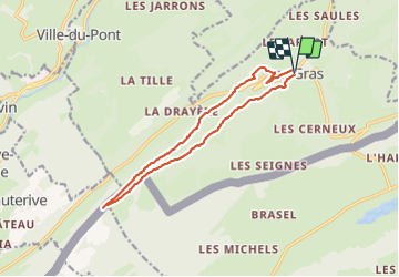

17,2 km | 27 km-effort

Gebruiker


Gratisgps-wandelapplicatie
 SityTrail
IGN / Geografische instituten
SityTrail World
De wereld gaat voor u open
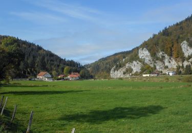
Tocht Stappen van 13,3 km beschikbaar op Bourgondië-Franche-Comté, Doubs, Les Gras. Deze tocht wordt voorgesteld door eltonnermou.
parking au centre du village, vers la poste
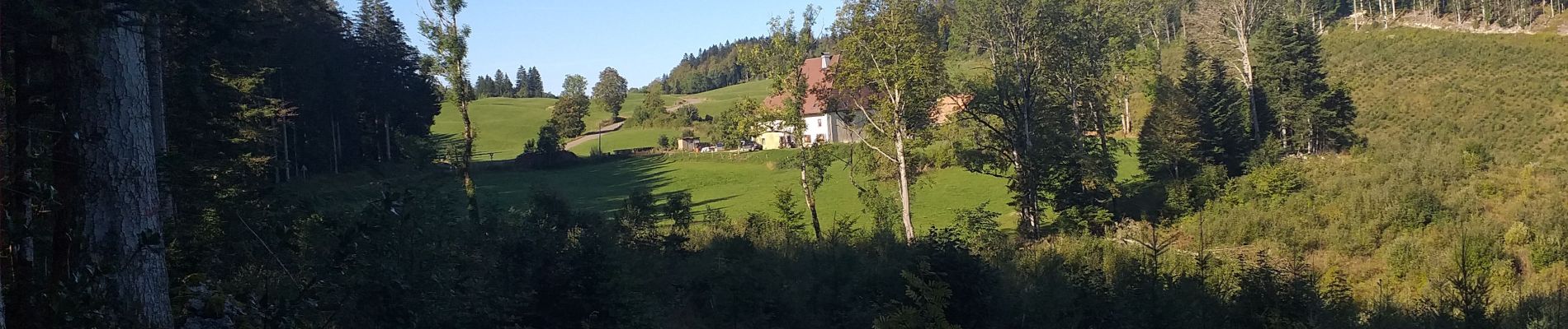
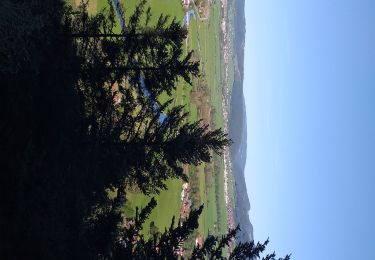
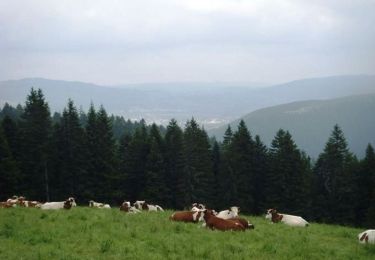
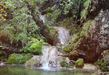
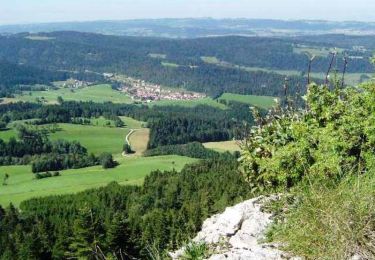
Très, très belle randonnée essentiellement en de magnifiques sous bois, avec des beaux points de vue sur le val de Morteau, des Gras ; sur les monts de la Suisse et du haut-doubs ; des passages en montée un peu plus engageants (bâtons fortement conseillés). Le retour est en quasi descente tout du long, ce qui est "reposant"
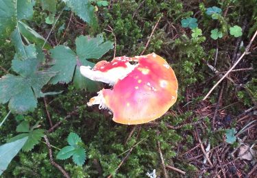
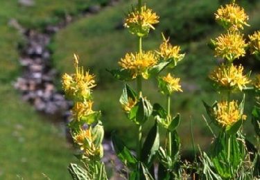
Et comme dans de tels paysages, laissez vous surprendre par la faune et la flore.
 "
data-pinterest-text="Pin it"
data-tweet-text="share on twitter"
data-facebook-share-url="https://www.sitytrail.com/nl/trails/3819062-les-gras--les-gras-xdoublex/?photo=1#lg=1&slide=1"
data-twitter-share-url="https://www.sitytrail.com/nl/trails/3819062-les-gras--les-gras-xdoublex/?photo=1#lg=1&slide=1"
data-googleplus-share-url="https://www.sitytrail.com/nl/trails/3819062-les-gras--les-gras-xdoublex/?photo=1#lg=1&slide=1"
data-pinterest-share-url="https://www.sitytrail.com/nl/trails/3819062-les-gras--les-gras-xdoublex/?photo=1#lg=1&slide=1">
"
data-pinterest-text="Pin it"
data-tweet-text="share on twitter"
data-facebook-share-url="https://www.sitytrail.com/nl/trails/3819062-les-gras--les-gras-xdoublex/?photo=1#lg=1&slide=1"
data-twitter-share-url="https://www.sitytrail.com/nl/trails/3819062-les-gras--les-gras-xdoublex/?photo=1#lg=1&slide=1"
data-googleplus-share-url="https://www.sitytrail.com/nl/trails/3819062-les-gras--les-gras-xdoublex/?photo=1#lg=1&slide=1"
data-pinterest-share-url="https://www.sitytrail.com/nl/trails/3819062-les-gras--les-gras-xdoublex/?photo=1#lg=1&slide=1">
 "
data-pinterest-text="Pin it"
data-tweet-text="share on twitter"
data-facebook-share-url="https://www.sitytrail.com/nl/trails/3819062-les-gras--les-gras-xdoublex/?photo=2#lg=1&slide=2"
data-twitter-share-url="https://www.sitytrail.com/nl/trails/3819062-les-gras--les-gras-xdoublex/?photo=2#lg=1&slide=2"
data-googleplus-share-url="https://www.sitytrail.com/nl/trails/3819062-les-gras--les-gras-xdoublex/?photo=2#lg=1&slide=2"
data-pinterest-share-url="https://www.sitytrail.com/nl/trails/3819062-les-gras--les-gras-xdoublex/?photo=2#lg=1&slide=2">
"
data-pinterest-text="Pin it"
data-tweet-text="share on twitter"
data-facebook-share-url="https://www.sitytrail.com/nl/trails/3819062-les-gras--les-gras-xdoublex/?photo=2#lg=1&slide=2"
data-twitter-share-url="https://www.sitytrail.com/nl/trails/3819062-les-gras--les-gras-xdoublex/?photo=2#lg=1&slide=2"
data-googleplus-share-url="https://www.sitytrail.com/nl/trails/3819062-les-gras--les-gras-xdoublex/?photo=2#lg=1&slide=2"
data-pinterest-share-url="https://www.sitytrail.com/nl/trails/3819062-les-gras--les-gras-xdoublex/?photo=2#lg=1&slide=2">
 "
data-pinterest-text="Pin it"
data-tweet-text="share on twitter"
data-facebook-share-url="https://www.sitytrail.com/nl/trails/3819062-les-gras--les-gras-xdoublex/?photo=3#lg=1&slide=3"
data-twitter-share-url="https://www.sitytrail.com/nl/trails/3819062-les-gras--les-gras-xdoublex/?photo=3#lg=1&slide=3"
data-googleplus-share-url="https://www.sitytrail.com/nl/trails/3819062-les-gras--les-gras-xdoublex/?photo=3#lg=1&slide=3"
data-pinterest-share-url="https://www.sitytrail.com/nl/trails/3819062-les-gras--les-gras-xdoublex/?photo=3#lg=1&slide=3">
"
data-pinterest-text="Pin it"
data-tweet-text="share on twitter"
data-facebook-share-url="https://www.sitytrail.com/nl/trails/3819062-les-gras--les-gras-xdoublex/?photo=3#lg=1&slide=3"
data-twitter-share-url="https://www.sitytrail.com/nl/trails/3819062-les-gras--les-gras-xdoublex/?photo=3#lg=1&slide=3"
data-googleplus-share-url="https://www.sitytrail.com/nl/trails/3819062-les-gras--les-gras-xdoublex/?photo=3#lg=1&slide=3"
data-pinterest-share-url="https://www.sitytrail.com/nl/trails/3819062-les-gras--les-gras-xdoublex/?photo=3#lg=1&slide=3">
 "
data-pinterest-text="Pin it"
data-tweet-text="share on twitter"
data-facebook-share-url="https://www.sitytrail.com/nl/trails/3819062-les-gras--les-gras-xdoublex/?photo=4#lg=1&slide=4"
data-twitter-share-url="https://www.sitytrail.com/nl/trails/3819062-les-gras--les-gras-xdoublex/?photo=4#lg=1&slide=4"
data-googleplus-share-url="https://www.sitytrail.com/nl/trails/3819062-les-gras--les-gras-xdoublex/?photo=4#lg=1&slide=4"
data-pinterest-share-url="https://www.sitytrail.com/nl/trails/3819062-les-gras--les-gras-xdoublex/?photo=4#lg=1&slide=4">
"
data-pinterest-text="Pin it"
data-tweet-text="share on twitter"
data-facebook-share-url="https://www.sitytrail.com/nl/trails/3819062-les-gras--les-gras-xdoublex/?photo=4#lg=1&slide=4"
data-twitter-share-url="https://www.sitytrail.com/nl/trails/3819062-les-gras--les-gras-xdoublex/?photo=4#lg=1&slide=4"
data-googleplus-share-url="https://www.sitytrail.com/nl/trails/3819062-les-gras--les-gras-xdoublex/?photo=4#lg=1&slide=4"
data-pinterest-share-url="https://www.sitytrail.com/nl/trails/3819062-les-gras--les-gras-xdoublex/?photo=4#lg=1&slide=4">
 "
data-pinterest-text="Pin it"
data-tweet-text="share on twitter"
data-facebook-share-url="https://www.sitytrail.com/nl/trails/3819062-les-gras--les-gras-xdoublex/?photo=5#lg=1&slide=5"
data-twitter-share-url="https://www.sitytrail.com/nl/trails/3819062-les-gras--les-gras-xdoublex/?photo=5#lg=1&slide=5"
data-googleplus-share-url="https://www.sitytrail.com/nl/trails/3819062-les-gras--les-gras-xdoublex/?photo=5#lg=1&slide=5"
data-pinterest-share-url="https://www.sitytrail.com/nl/trails/3819062-les-gras--les-gras-xdoublex/?photo=5#lg=1&slide=5">
"
data-pinterest-text="Pin it"
data-tweet-text="share on twitter"
data-facebook-share-url="https://www.sitytrail.com/nl/trails/3819062-les-gras--les-gras-xdoublex/?photo=5#lg=1&slide=5"
data-twitter-share-url="https://www.sitytrail.com/nl/trails/3819062-les-gras--les-gras-xdoublex/?photo=5#lg=1&slide=5"
data-googleplus-share-url="https://www.sitytrail.com/nl/trails/3819062-les-gras--les-gras-xdoublex/?photo=5#lg=1&slide=5"
data-pinterest-share-url="https://www.sitytrail.com/nl/trails/3819062-les-gras--les-gras-xdoublex/?photo=5#lg=1&slide=5">
 "
data-pinterest-text="Pin it"
data-tweet-text="share on twitter"
data-facebook-share-url="https://www.sitytrail.com/nl/trails/3819062-les-gras--les-gras-xdoublex/?photo=6#lg=1&slide=6"
data-twitter-share-url="https://www.sitytrail.com/nl/trails/3819062-les-gras--les-gras-xdoublex/?photo=6#lg=1&slide=6"
data-googleplus-share-url="https://www.sitytrail.com/nl/trails/3819062-les-gras--les-gras-xdoublex/?photo=6#lg=1&slide=6"
data-pinterest-share-url="https://www.sitytrail.com/nl/trails/3819062-les-gras--les-gras-xdoublex/?photo=6#lg=1&slide=6">
"
data-pinterest-text="Pin it"
data-tweet-text="share on twitter"
data-facebook-share-url="https://www.sitytrail.com/nl/trails/3819062-les-gras--les-gras-xdoublex/?photo=6#lg=1&slide=6"
data-twitter-share-url="https://www.sitytrail.com/nl/trails/3819062-les-gras--les-gras-xdoublex/?photo=6#lg=1&slide=6"
data-googleplus-share-url="https://www.sitytrail.com/nl/trails/3819062-les-gras--les-gras-xdoublex/?photo=6#lg=1&slide=6"
data-pinterest-share-url="https://www.sitytrail.com/nl/trails/3819062-les-gras--les-gras-xdoublex/?photo=6#lg=1&slide=6">
 "
data-pinterest-text="Pin it"
data-tweet-text="share on twitter"
data-facebook-share-url="https://www.sitytrail.com/nl/trails/3819062-les-gras--les-gras-xdoublex/?photo=7#lg=1&slide=7"
data-twitter-share-url="https://www.sitytrail.com/nl/trails/3819062-les-gras--les-gras-xdoublex/?photo=7#lg=1&slide=7"
data-googleplus-share-url="https://www.sitytrail.com/nl/trails/3819062-les-gras--les-gras-xdoublex/?photo=7#lg=1&slide=7"
data-pinterest-share-url="https://www.sitytrail.com/nl/trails/3819062-les-gras--les-gras-xdoublex/?photo=7#lg=1&slide=7">
"
data-pinterest-text="Pin it"
data-tweet-text="share on twitter"
data-facebook-share-url="https://www.sitytrail.com/nl/trails/3819062-les-gras--les-gras-xdoublex/?photo=7#lg=1&slide=7"
data-twitter-share-url="https://www.sitytrail.com/nl/trails/3819062-les-gras--les-gras-xdoublex/?photo=7#lg=1&slide=7"
data-googleplus-share-url="https://www.sitytrail.com/nl/trails/3819062-les-gras--les-gras-xdoublex/?photo=7#lg=1&slide=7"
data-pinterest-share-url="https://www.sitytrail.com/nl/trails/3819062-les-gras--les-gras-xdoublex/?photo=7#lg=1&slide=7">
 "
data-pinterest-text="Pin it"
data-tweet-text="share on twitter"
data-facebook-share-url="https://www.sitytrail.com/nl/trails/3819062-les-gras--les-gras-xdoublex/?photo=8#lg=1&slide=8"
data-twitter-share-url="https://www.sitytrail.com/nl/trails/3819062-les-gras--les-gras-xdoublex/?photo=8#lg=1&slide=8"
data-googleplus-share-url="https://www.sitytrail.com/nl/trails/3819062-les-gras--les-gras-xdoublex/?photo=8#lg=1&slide=8"
data-pinterest-share-url="https://www.sitytrail.com/nl/trails/3819062-les-gras--les-gras-xdoublex/?photo=8#lg=1&slide=8">
"
data-pinterest-text="Pin it"
data-tweet-text="share on twitter"
data-facebook-share-url="https://www.sitytrail.com/nl/trails/3819062-les-gras--les-gras-xdoublex/?photo=8#lg=1&slide=8"
data-twitter-share-url="https://www.sitytrail.com/nl/trails/3819062-les-gras--les-gras-xdoublex/?photo=8#lg=1&slide=8"
data-googleplus-share-url="https://www.sitytrail.com/nl/trails/3819062-les-gras--les-gras-xdoublex/?photo=8#lg=1&slide=8"
data-pinterest-share-url="https://www.sitytrail.com/nl/trails/3819062-les-gras--les-gras-xdoublex/?photo=8#lg=1&slide=8">
 "
data-pinterest-text="Pin it"
data-tweet-text="share on twitter"
data-facebook-share-url="https://www.sitytrail.com/nl/trails/3819062-les-gras--les-gras-xdoublex/?photo=9#lg=1&slide=9"
data-twitter-share-url="https://www.sitytrail.com/nl/trails/3819062-les-gras--les-gras-xdoublex/?photo=9#lg=1&slide=9"
data-googleplus-share-url="https://www.sitytrail.com/nl/trails/3819062-les-gras--les-gras-xdoublex/?photo=9#lg=1&slide=9"
data-pinterest-share-url="https://www.sitytrail.com/nl/trails/3819062-les-gras--les-gras-xdoublex/?photo=9#lg=1&slide=9">
"
data-pinterest-text="Pin it"
data-tweet-text="share on twitter"
data-facebook-share-url="https://www.sitytrail.com/nl/trails/3819062-les-gras--les-gras-xdoublex/?photo=9#lg=1&slide=9"
data-twitter-share-url="https://www.sitytrail.com/nl/trails/3819062-les-gras--les-gras-xdoublex/?photo=9#lg=1&slide=9"
data-googleplus-share-url="https://www.sitytrail.com/nl/trails/3819062-les-gras--les-gras-xdoublex/?photo=9#lg=1&slide=9"
data-pinterest-share-url="https://www.sitytrail.com/nl/trails/3819062-les-gras--les-gras-xdoublex/?photo=9#lg=1&slide=9">
 "
data-pinterest-text="Pin it"
data-tweet-text="share on twitter"
data-facebook-share-url="https://www.sitytrail.com/nl/trails/3819062-les-gras--les-gras-xdoublex/?photo=10#lg=1&slide=10"
data-twitter-share-url="https://www.sitytrail.com/nl/trails/3819062-les-gras--les-gras-xdoublex/?photo=10#lg=1&slide=10"
data-googleplus-share-url="https://www.sitytrail.com/nl/trails/3819062-les-gras--les-gras-xdoublex/?photo=10#lg=1&slide=10"
data-pinterest-share-url="https://www.sitytrail.com/nl/trails/3819062-les-gras--les-gras-xdoublex/?photo=10#lg=1&slide=10">
"
data-pinterest-text="Pin it"
data-tweet-text="share on twitter"
data-facebook-share-url="https://www.sitytrail.com/nl/trails/3819062-les-gras--les-gras-xdoublex/?photo=10#lg=1&slide=10"
data-twitter-share-url="https://www.sitytrail.com/nl/trails/3819062-les-gras--les-gras-xdoublex/?photo=10#lg=1&slide=10"
data-googleplus-share-url="https://www.sitytrail.com/nl/trails/3819062-les-gras--les-gras-xdoublex/?photo=10#lg=1&slide=10"
data-pinterest-share-url="https://www.sitytrail.com/nl/trails/3819062-les-gras--les-gras-xdoublex/?photo=10#lg=1&slide=10">
 "
data-pinterest-text="Pin it"
data-tweet-text="share on twitter"
data-facebook-share-url="https://www.sitytrail.com/nl/trails/3819062-les-gras--les-gras-xdoublex/?photo=11#lg=1&slide=11"
data-twitter-share-url="https://www.sitytrail.com/nl/trails/3819062-les-gras--les-gras-xdoublex/?photo=11#lg=1&slide=11"
data-googleplus-share-url="https://www.sitytrail.com/nl/trails/3819062-les-gras--les-gras-xdoublex/?photo=11#lg=1&slide=11"
data-pinterest-share-url="https://www.sitytrail.com/nl/trails/3819062-les-gras--les-gras-xdoublex/?photo=11#lg=1&slide=11">
"
data-pinterest-text="Pin it"
data-tweet-text="share on twitter"
data-facebook-share-url="https://www.sitytrail.com/nl/trails/3819062-les-gras--les-gras-xdoublex/?photo=11#lg=1&slide=11"
data-twitter-share-url="https://www.sitytrail.com/nl/trails/3819062-les-gras--les-gras-xdoublex/?photo=11#lg=1&slide=11"
data-googleplus-share-url="https://www.sitytrail.com/nl/trails/3819062-les-gras--les-gras-xdoublex/?photo=11#lg=1&slide=11"
data-pinterest-share-url="https://www.sitytrail.com/nl/trails/3819062-les-gras--les-gras-xdoublex/?photo=11#lg=1&slide=11">
 "
data-pinterest-text="Pin it"
data-tweet-text="share on twitter"
data-facebook-share-url="https://www.sitytrail.com/nl/trails/3819062-les-gras--les-gras-xdoublex/?photo=12#lg=1&slide=12"
data-twitter-share-url="https://www.sitytrail.com/nl/trails/3819062-les-gras--les-gras-xdoublex/?photo=12#lg=1&slide=12"
data-googleplus-share-url="https://www.sitytrail.com/nl/trails/3819062-les-gras--les-gras-xdoublex/?photo=12#lg=1&slide=12"
data-pinterest-share-url="https://www.sitytrail.com/nl/trails/3819062-les-gras--les-gras-xdoublex/?photo=12#lg=1&slide=12">
"
data-pinterest-text="Pin it"
data-tweet-text="share on twitter"
data-facebook-share-url="https://www.sitytrail.com/nl/trails/3819062-les-gras--les-gras-xdoublex/?photo=12#lg=1&slide=12"
data-twitter-share-url="https://www.sitytrail.com/nl/trails/3819062-les-gras--les-gras-xdoublex/?photo=12#lg=1&slide=12"
data-googleplus-share-url="https://www.sitytrail.com/nl/trails/3819062-les-gras--les-gras-xdoublex/?photo=12#lg=1&slide=12"
data-pinterest-share-url="https://www.sitytrail.com/nl/trails/3819062-les-gras--les-gras-xdoublex/?photo=12#lg=1&slide=12">
 "
data-pinterest-text="Pin it"
data-tweet-text="share on twitter"
data-facebook-share-url="https://www.sitytrail.com/nl/trails/3819062-les-gras--les-gras-xdoublex/?photo=13#lg=1&slide=13"
data-twitter-share-url="https://www.sitytrail.com/nl/trails/3819062-les-gras--les-gras-xdoublex/?photo=13#lg=1&slide=13"
data-googleplus-share-url="https://www.sitytrail.com/nl/trails/3819062-les-gras--les-gras-xdoublex/?photo=13#lg=1&slide=13"
data-pinterest-share-url="https://www.sitytrail.com/nl/trails/3819062-les-gras--les-gras-xdoublex/?photo=13#lg=1&slide=13">
"
data-pinterest-text="Pin it"
data-tweet-text="share on twitter"
data-facebook-share-url="https://www.sitytrail.com/nl/trails/3819062-les-gras--les-gras-xdoublex/?photo=13#lg=1&slide=13"
data-twitter-share-url="https://www.sitytrail.com/nl/trails/3819062-les-gras--les-gras-xdoublex/?photo=13#lg=1&slide=13"
data-googleplus-share-url="https://www.sitytrail.com/nl/trails/3819062-les-gras--les-gras-xdoublex/?photo=13#lg=1&slide=13"
data-pinterest-share-url="https://www.sitytrail.com/nl/trails/3819062-les-gras--les-gras-xdoublex/?photo=13#lg=1&slide=13">
 "
data-pinterest-text="Pin it"
data-tweet-text="share on twitter"
data-facebook-share-url="https://www.sitytrail.com/nl/trails/3819062-les-gras--les-gras-xdoublex/?photo=14#lg=1&slide=14"
data-twitter-share-url="https://www.sitytrail.com/nl/trails/3819062-les-gras--les-gras-xdoublex/?photo=14#lg=1&slide=14"
data-googleplus-share-url="https://www.sitytrail.com/nl/trails/3819062-les-gras--les-gras-xdoublex/?photo=14#lg=1&slide=14"
data-pinterest-share-url="https://www.sitytrail.com/nl/trails/3819062-les-gras--les-gras-xdoublex/?photo=14#lg=1&slide=14">
"
data-pinterest-text="Pin it"
data-tweet-text="share on twitter"
data-facebook-share-url="https://www.sitytrail.com/nl/trails/3819062-les-gras--les-gras-xdoublex/?photo=14#lg=1&slide=14"
data-twitter-share-url="https://www.sitytrail.com/nl/trails/3819062-les-gras--les-gras-xdoublex/?photo=14#lg=1&slide=14"
data-googleplus-share-url="https://www.sitytrail.com/nl/trails/3819062-les-gras--les-gras-xdoublex/?photo=14#lg=1&slide=14"
data-pinterest-share-url="https://www.sitytrail.com/nl/trails/3819062-les-gras--les-gras-xdoublex/?photo=14#lg=1&slide=14">

Stappen
Stappen
Stappen
Stappen
Stappen
Stappen
Mountainbike

Andere activiteiten

Stappen